Thank you for taking the time to visit our website about our plans for the proposed residential development and new country park, at land off Whitmore Road, Newcastle-under-Lyme.
Due to a delay in the leaflet distribution advertising this consultation, the deadline to respond to this consultation is extended until 7 December 2025, instead of 30 November as stated on the leaflet.
Richborough invite you to take part in our public consultation for the proposed development at Land off Whitmore Road, Newcastle-under-Lyme, which is identified as a housing allocation in the new Local Plan for the Borough (site allocation reference TB19) as shown on the Council’s proposals map extract.
The full Local Plan proposals map can be viewed here.
Knights are Richborough’s appointed planning consultants and will be responsible for submitting the planning application.
Richborough are proposing to deliver a high-quality development of in the region of 650 dwellings, helping local people to get on the housing ladder or find their forever home. Too many people are forced to move out of the area they grew up in to find a new home because of the worsening housing crisis across the country. Our proposals include a range of 2,3, 4 and 5-bedroom homes suitable for a range of households, including first time buyers and young families, and some new homes suitable for older people.
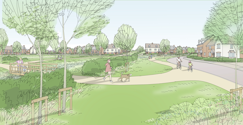
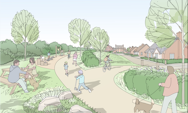
Our proposals go beyond bricks and mortar – it takes more than a new house to make a community. Our plans include extensive areas of green infrastructure, including a publicly accessible country park to the southwest of the site which will be accessible for all. Various children’s equipped play areas will be included, in addition to providing pedestrians and cyclists with connections to the wider network of open space and key routes. Creating a place that feels like home takes more than four walls and a roof – it’s about creating a positive environment to live in.
The scheme will create new employment opportunities during the construction phase, both directly and indirectly through the supply chain. The development industry, including its supply chain, is a major contributor to both national and local economies as part of the wider construction sector, both through the employment it creates and the investment it makes in the sites being built. In addition, new residents will increase footfall for existing shops and other local businesses and sports and social clubs.
This website presents details of the proposed development and provides you with the opportunity to make comments on the scheme. Once this process is concluded, a planning application will be submitted to Newcastle-under-Lyme Bough Council.
Established for over 20 years, Richborough is at the forefront of the UK’s strategic land promotion industry.
Richborough use a responsible approach to design and secure planning permission for high quality residential and commercial developments.
Richborough’s teams comprise chartered industry professionals including planners, surveyors, architects, urban designers and engineers.
Richborough’s approach ensures that their masterplans and design legacies can be easily delivered by their housebuilding partners, enhancing communities for generations to come.
You can find out more about Richborough on their website.
 A completed Richborough promoted site in Matlock
Wider Context
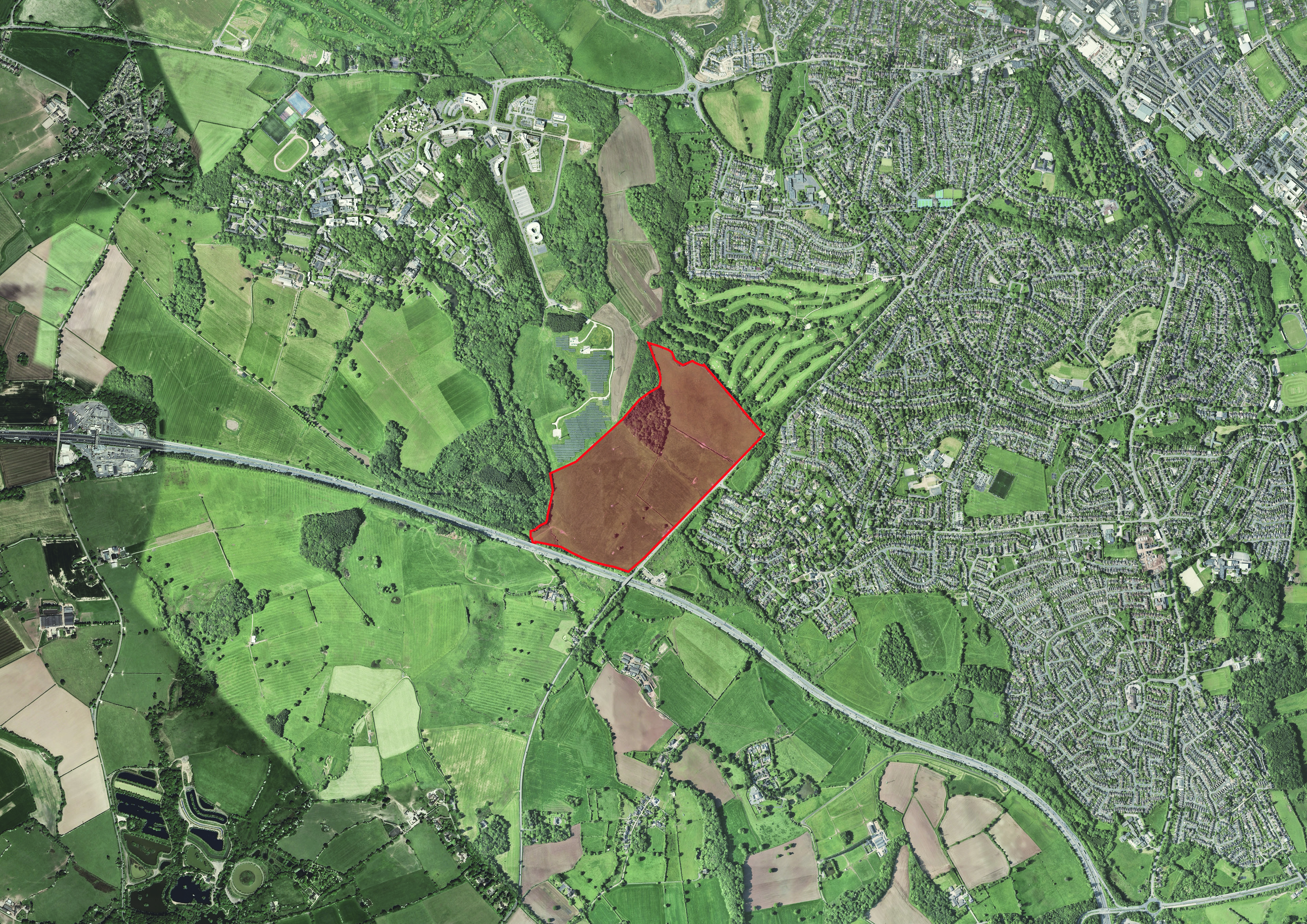
The site is located to the west of the combined main urban area of Stoke-on-Trent and Newcastle-under-Lyme, being located within the Newcastle-under-Lyme administrative area.
Local Context
The site is located to the southwest of Newcastle-under-Lyme town centre, to the west of Whitmore Road. To the east of Whitmore Road are the housing estates known as The Westlands and Seabridge. The south of the site is the M6 Motorway. To the northwest of the site is the Keele University campus and Keele Science and Innovation Park. To the northeast of the site is Newcastle-under-Lyme Golf Club. To the north of the site is the housing estate known as Thistleberry. Whitmore Road forms the main A53 Road between Newcastle-under-Lyme and Shrewsbury.
Whitmore Road is a two-way single carriageway and is subject to the national speed restriction to the southwest of the site, which changes to a 40-mph speed restriction approximately 230 metres east of the site’s western boundary.
Site Description
The site comprises open fields, currently in use as agricultural pasture. The site directly abuts Whitmore Road and benefits from direct access to the highway. Whitmore Road has a footway running along the site frontage which leads towards Newcastle-under-Lyme Town Centre.
The site is bounded by a hawthorn hedgerow. The individual field parcels within the site also comprise hawthorn hedgerows.
In terms of topography, the site gently rises from Whitmore Road to the east, towards the boundaries of Keele University to the northwest. A belt of trees exists to the north of the site.
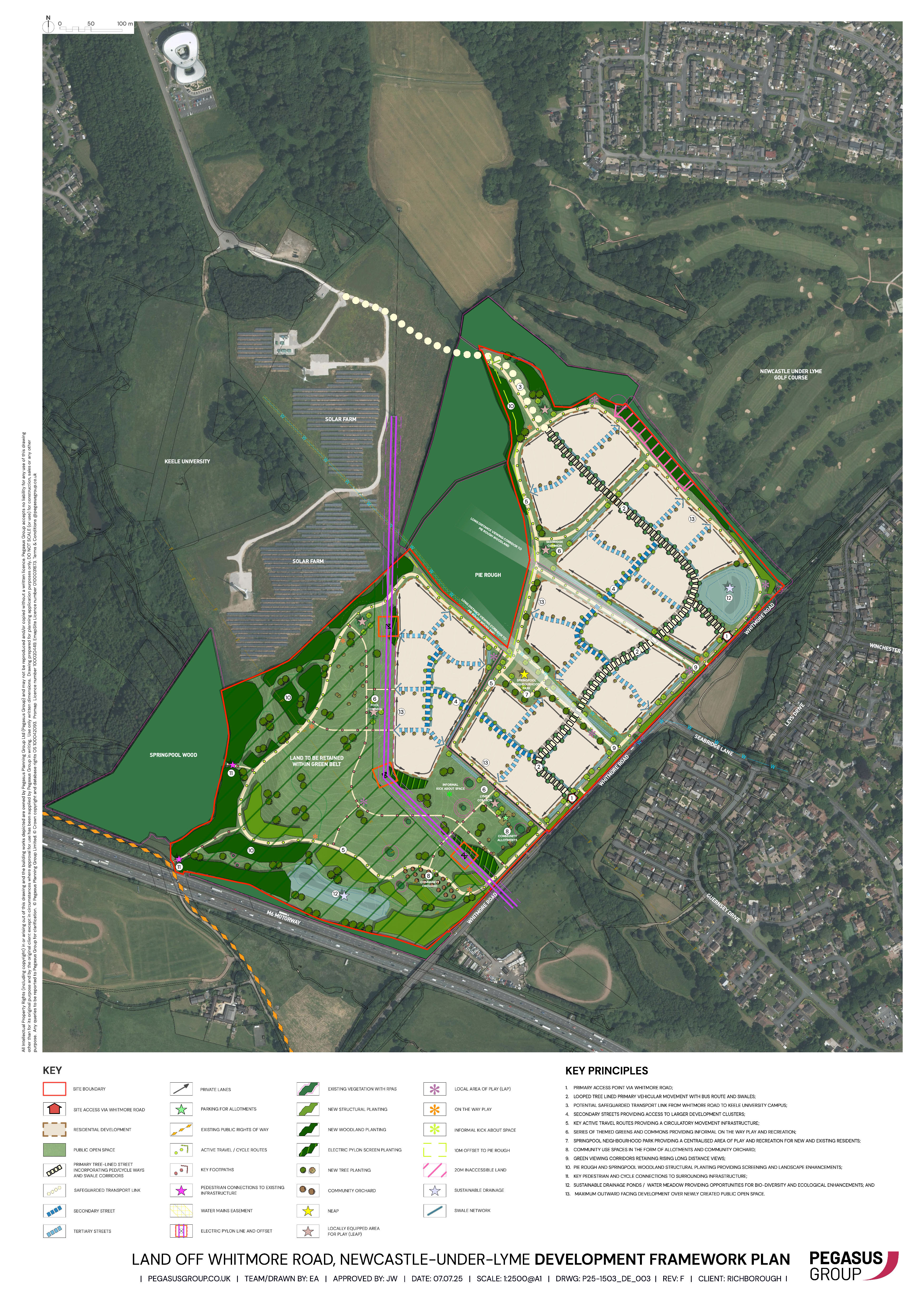
Richborough are proposing to submit an outline planning application for in the region of 650 dwellings. The outline planning application will establish the parameters for the proposed development with the final details to be determined later through a process known as the reserved matters application stage.
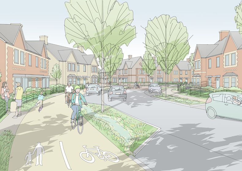
Placemaking is at the core of the design process to create a high-quality development that places the needs of future and existing residents first. Our proposals take account of the site’s surroundings and the opportunities this presents to integrate seamlessly into the wider area.
We want to deliver attractive, high quality and sustainable new homes, which will create a distinct sense of place and identity for future residents. Extensive open space, including a country park will be provided which will be accessible to all.
In summary, the proposed development will comprise:
- In the region of 650 homes.
- Vehicular access from Whitmore Road.
- Safeguarded land for a future road through the development to Keele University to accommodate a potential future bus link to the University.
- Active and passive recreation including a new country park, children’s play areas, community orchards and allotments. This means residents can use these spaces for physical activity such as walking or working an allotment, or simply as somewhere to enjoy the view – hence the term active and passive.
- Provision of a minimum 10% biodiversity net gain (see the Ecology and Biodiversity section).
- A network of connected open space and active travel (e.g. walking, running and cycling) opportunities.
- Mix of housing size, type, and tenure to meet local need.
- 30% affordable housing provision on-site to meet the Borough Council’s requirements.
- Reduction of the speed limit along Whitmore Road to 30mph and the provision of a signalised pedestrian crossing to provide a safe walking and crossing route to enable the wider community to walk to the proposed country park; and
- Financial contributions towards increasing capacity at local GP surgeries and schools.

The proposed development would consider a range of technical matters, including the location of existing utilities, watercourses and other features.
Flooding and Drainage
The site lies within the Government’s Flood Zone 1 so is at the lowest risk of flooding.
To promote climate resilience the proposals will include a comprehensive drainage strategy that incorporates sustainable urban drainage systems, such as ponds and swales that will attenuate surface water on site and gradually divert water into the surface water drainage network over a longer period, to avoid overwhelming the local drainage network during periods of heavy rainfall. In short, the development will hold back water in the ponds and swales so that it does not overload the local network.
Ecology and Biodiversity
Ecological Surveys will be submitted as part of the planning application to assess the site's biodiversity and ensure that the proposed development protects and potentially enhances local habitats and species.
The Environment Act 2021 now expects all development sites to deliver a minimum of 10% Biodiversity Net Gain (BNG), which can be met either on site or off site. A biodiversity impact assessment and biodiversity metric will be submitted as part of the planning application to demonstrate that a minimum 10% BNG can be achieved through the proposals.
Traffic
A full Transport Assessment will be submitted as part of the planning application to assess the full transport impacts of the proposal.
Vehicular access to the site is proposed via two ghost island priority junctions from Whitmore Road so vehicles can pull into a turning lane in the middle of the road before entering the site. The two access points will be located at suitable offsets (more than 100m) from the Seabridge Lane junction.
The site access junctions will be designed to accommodate bus provision. An option is for the existing no.64 bus service to be diverted into the site from Whitmore Road.
The existing no.64 bus service could also be enhanced in respect of frequency; further details regarding the bus service will be discussed with the highway authority in due course.
The site will help to facilitate the link road through to Keele University to the north, which will also be utilised to deliver additional high frequency bus provision in line with the Staffordshire Bus Service Improvement Plan (BSIP) 2024 to 2050.
In addition to the site access junctions, it is proposed to reduce vehicular speeds along Whitmore Road by extending the 30mph speed limit and introduce a new 40mph speed limit immediately west of the M6, to provide a stepped approach to the speed reduction as drivers enter the built-up area.
Further to the above, the site will deliver high quality pedestrian and cycle routes throughout, connecting to Whitmore Road at a new pedestrian crossing facility, providing safe and convenient access to Seabridge Lane and the local facilities within the Seabridge estate to the east. This would also provide a safe crossing route for residents on the Seabridge estate who may wish to access the proposed country park.
Landscaping
A publicly accessible area of open space in the form of a country park will be located to the southwest of the development. In addition, smaller areas of open space and play areas will be provided throughout the development. The main streets through the development would also include the provision of street trees. Wide grass verges to some streets would include the provision of drainage swales that would be landscaped in an attractive manner and include a planting strategy to increase biodiversity. The proposed landscaping strategy would create a balanced environment for leisure and appreciation of natural beauty and to ensure easy access for the wider community.
The pattern of new development will feature thoughtful landscape design elements and focal points to create a distinctive and attractive streetscape. The proposed landscaping strategy for the site is available here.
Services and Facilities
The development will make financial contributions towards increasing capacity at local GP surgeries and schools.
Our proposals would benefit the local community by providing the following.
Social Benefits
- The provision of new family homes to meet an identified need for new housing within the Borough, including the provision of some new affordable homes for local people.
- New open space provision within the site, including the country park, other green space areas and play areas; and
- Improved public transport linkages through the provision of internal road infrastructure to facilitate potential future bus linkages to Keele University.
Economic benefits
- Increased spending in local shops and facilities, at a time when the retail industry is facing significant challenges.
- Increased spending on local leisure, trades and services will support new jobs in those industries.
- The creation of new jobs during the construction phase, including potentially apprenticeships for residents.
- Ensuring there is sufficient housing to meet the needs of the Borough and future job creation; and
- An increase in council tax revenue for the Borough to support services and facilities.
Environmental benefits
- The provision of new and improved open green space throughout the development, including a publicly accessible country park.
- The provision of green infrastructure through the retention of existing tree and hedgerows and the provision of additional planting and landscaping throughout the site; and,
- Delivery of a minimum 10% biodiversity net gain through a combination of on-site and off-site habitat creation.
We are working towards submitting the full planning application to Newcastle-under-Lyme Borough Council later in 2025. The submission will be supported by a series of technical assessments to demonstrate the suitability of the proposed development.
We would like your views on the proposals and request that all responses are made by Sunday 7 December 2025. Please submit your feedback using this form.
Once the planning application is submitted, Newcastle-under-Lyme Borough Council will provide another opportunity for you to formally comment on the development proposals as part of their planning application consultation process (please note that the Council will not be able to respond to comments made at this pre-application stage and comments should be provided to us in response to this consultation).
How to get in touch
If you need any further information, please contact Alan Corinaldi-Knott by emailing alan.corinaldi-knott@knightsplc.com or phoning 01782 619225.
Alternatively please write to us at: Planning Team, Knights, The Brampton, Newcastle-under-Lyme, Staffordshire, ST5 0QW.
Please note that the plans may be subject to amendments following receipt of your comments.